Rice University logo
 
Top blue bar image
in Fondren Library at Rice University
 

Archive for November, 2009


Thursday Data: Houston Area Data Sources

November 12th, 2009 by GIS/Data Center

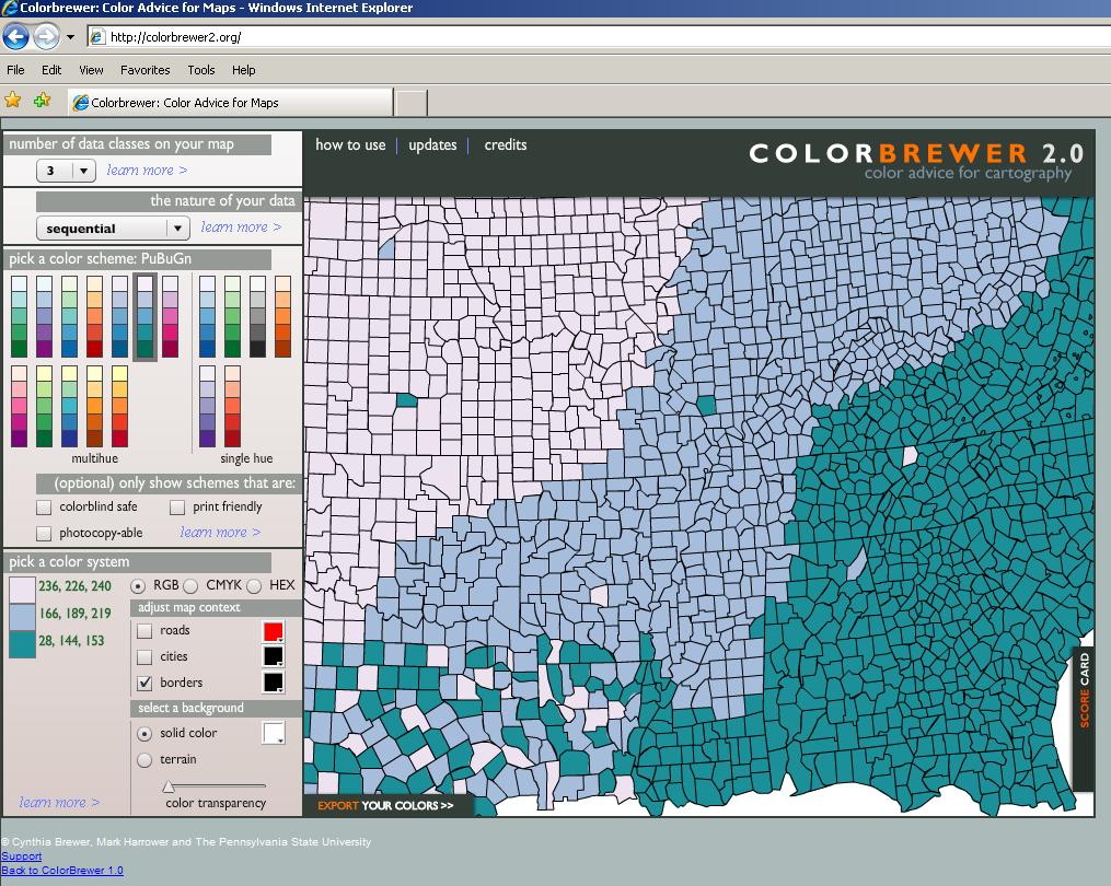
For those looking for free GIS data covering the greater Houston area, there are several government organizations that make such data available for public download.

The City of Houston maintains a GIS website where users can download shapefile datasets.  Each dataset contains numerous shapefiles grouped by category, such as administrative boundaries, locations, and routes.  Unfortunately, it is not possible to select individual shapefiles out of the larger datasets for download.  The data is updated and released every year or two.  A new release was scheduled for this summer, but has been delayed.

The Architecture and Engineering Division of the Harris County Public Infrastructure Department also maintains a GIS website where users can preview and download individual shapefiles relating to reference grids, boundaries, transportation, water, parks and services.

The Harris County Appraisal District maintains a Public Data website where users can download both individual shapefiles and text files for import into Access databases, which can then be joined to the related shapefiles using GIS.  Unsurprisingly, the best feature of the HCAD site is the ability to obtain detailed shapefiles and property information for all parcels in Harris County.  The shapefiles were recently updated in October, 2009 and the data tables are updated bi-weekly.

The Houston-Galveston Area Council (HGAC) serves as Houston’s Council of Governments (COG), or regional planning organization.  HGAC supports local governments inside their 13-county service region and maintains a GIS Data Clearinghouse where users can download individual shapefiles relating to boundaries, cultural features, transportation, water, land, and elevation.  Because HGAC serves a larger region than the Houston and Harris County governments, their datasets are typically more expansive in coverage.  It is also worth exploring the numerous sections of their Regional Data & GIS Services website for information on demographics, economics, transportation, land use, and water quality in the region.

For members of the Rice community, we maintain several additional datasets for the Houston region at the GIS/Data Center that are not available online, including georeferenced historic and current aerial photography and LiDAR digital elevation models.

Web Wednesday: Make A Map

November 11th, 2009 by GIS/Data Center

ESRI, the company behind ArcGIS software, has created an interactive web interface, called Make A Map, that allows users to create and share displays of basic U.S. demographic layers. Guests have the choice of seven different demographic statistics from which to make their map, each with a fixed graduated color ramp. As users zoom in on the map, the demographic representation changes automatically from the state level down to the county, census tract, and census block group level. Users are free to zoom to locations of interest (hometown, university, state, etc.), change the demographic variables, and embed their new map creation in their own webpage to share with others.

ESRI’s main goal for this Web application is to “encourage you to freely create and share demographic Web maps,” as well as to provide a quick and simple overview of some of the Web Mapping API (Application Programming Interface) technology that is becoming available. For more information about ESRI’s other free mapping tools, visit Mapping for Everyone.

Below is an example embedded map showing the median age distribution of persons around the West University/Museum District area.  Explore the map below and then make your own map to share.

Tuesday Tools: ColorBrewer – Part 1

November 10th, 2009 by GIS/Data Center

One of the most important aspects of creating a map that effectively communicates information is an appropriately chosen color scheme. Colors used in a map are instrumental in displaying trends or relationships, and they ultimately impact how your map is perceived. Color selection is particularly important when choosing color ramps, which apply a continuous range of colors to a group of symbols on your map. ArcMap has predefined color ramps and gives you the option to create your own. Choosing colors is not easy for all of us, which is why ColorBrewer, a web tool for selecting colors for maps, is so useful. ColorBrewer facilitates the process of creating and testing customized, intelligent color selections based on the nature of your data.

An updated version, ColorBrewer 2.0, was recently released by Axis Maps. The new version has a larger selection of colors to customize the symbology of map features, including roads, cities, and boundary lines. You can also turn on a hillshade layer in the background and use transparency settings to see how well color schemes function as transparent overlays. Another new feature of ColorBrewer 2.0 is the ability to filter color schemes based on colorblind-safe, print-friendly, or photocopy-friendly settings so you can select which ones are suitable for the intended use of your map. The new version also allows you to export your color schemes into Adobe Illustrator, Photoshop, or Excel. Perhaps, the best feature of the new version is the ability to download an ArcMap plug-in, called ColorTool, which allows you to directly apply ColorBrewer color ramps to your own maps. Check back next Tuesday for more information on this free plug-in!

Note: ColorBrewer 2.0 requires Adobe Flash Player 10. If you can’t download Adobe Flash Player 10, the original version of ColorBrewer is still available.

Color Brewer Version 2.0

ColorBrewer’s creator, Cynthia A. Brewer, is the author of Designing Better Maps: A Guide for GIS Users, which is available in the general stacks of Fondren Library. In addition to detailed information about map design, the book includes an appendix describing the ColorBrewer application, as well as printed color charts.

For hands-on training, Rice students, staff, and faculty have free access to ESRI’s online course, titled Cartographic Design Using ArcGIS 9, which was authored by Dr. Brewer.  Two of the seven modules in the course relate specifically to color design.  Those wishing to take the self-paced, online course may log a ticket with Rice IT to request a course access code.  Anyone may also purchase access to the course for $174.

Welcome to the GIS/Data Center Blog

November 9th, 2009 by GIS/Data Center

Welcome to the first of many blog posts brought to you by the staff of the GIS/Data Center in Fondren Library at Rice University. GIS stands for Geographic Information Systems and makes use of hardware and software to support people in displaying, querying, manipulating, and analyzing spatial data.

This blog will be geared towards the Rice community and will highlight resources at the GIS/Data Center and in the Houston area; however, most of the information will be equally applicable to anyone with an interest in or curiosity about GIS. We will be highlighting data, tools, techniques, and applications that we hope will be useful to those just getting started, as well as those with more experience who are looking for new and exciting innovations in the field. Therefore, our posts will feature a mixture of recent developments and well-established practices.

We’ve come up with some fun daily themes to keep you reading and us writing:

Miscellaneous Monday – general GIS news, Houston and Fondren Library GIS information and events, Rice faculty and student projects utilizing GIS

Tuesday Tools – tools that can be used online or downloaded to perform special functions in GIS and cartography

Web Wednesday – websites that either allow you to browse and query existing data online or to create online content using your own data

Thursday Data – sources of free, high-quality, GIS-related data

Fun Friday – interesting, novel, and downright fun maps and applications

If you would like more information or one-on-one training related to the any of the topics covered in the blog, feel free to visit us at the GIS/Data Center in the basement of Fondren Library (B40). Please also refer to our website for our contact information and more details regarding our computer lab, data, training, and assistance.

While comments will not be displayed on this blog, we do welcome your feedback and will take your comments into consideration for the future development of our blog.